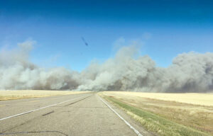
Cypress Country Fire Services IS utilizing an advanced satellite system to detect wildfires through a new pilot program and collaboration with a German-based technology company. For approximately three weeks the county, which is more than 13,000 square kilometres in size, has been under watch by the sensitive equipment orbiting the globe. Smoke from the October 2017 wildfire near Hilda is seen in this file photo.--FILE PHOTO
bmiller@medicinehatnews.com
A series of satellites designed for wildfire detection now have their “eyes” on Cypress County as the jurisdiction becomes the first in Canada outside Quebec to run a pilot project with a German-based company to detect wildfires, and even prevent them from sparking.
Cypress County Fire Services says the county has been under wildfire surveillance provided by OroraTech, which uses 25 satellites and ground sources to detect hotspots and monitor areas at risk of wildfires, for approximately three weeks now.
In that short period of time the system’s sensitive equipment has already picked up each fire the department has responded to.
Once the system detects a fire or high risk, that information is relayed to first responders in real time. The system also provides alerts that include exact co-ordinates, data on the fire’s intensity and an estimation of the area the fire will affect.
Once a fire detection or alert is sent, first responders are dispatched from the nearest fire station, as well as support from HALO air ambulance and a duty officer.
“It has picked up fires that we have responded to almost the same time that we got notified of them, so we know that it does work,” says fire chief Jason Linton. “There is some lag time between detection, notification and verifying, but it adds a layer of protection or another tool in our box to detect and respond to fires.”
The system works well enough that it has already potentially prevented at least on fire from starting after detecting a hot spot near the U.S border.
“We did have a detection right down by the U.S border so we notified Elkwater station, or Station No. 5, and then I went with HALO to get eyes on it faster to see if it was an actual fire,” recalls Linton. “There was a heat detection, but there was no fire, it was a hay bale that actually was starting to heat up from the inside due to the moisture content.”
Although Linton can’t confirm the bale would have for sure sparked a fire, the detection of the temperature increase displays the system’s adaptation of high-resolution thermal equipment that provides detection for fires as small as 10×10 metres.
“There was no fire but it was so sensitive we actually detected a heat signature from a bail.”
Cypress County is running the pilot program throughout the summer to help monitor its uniquely large area that includes extensive areas with no human activity.
“We’re a very, very large county, over 13,000 square kilometres, and lots of the county is vast areas where there are not a lot of residents or people travelling through it,” explains Linton. “A lot of our fires start because of lightning, and it could go hours undetected.”
Linton says this has been a concern throughout consultation with landowners and producers.
“Sometimes they will stay up all night because they’re worried about fires starting and having mass fires on their crops and their grazing land, it keeps them up at night,” says Linton. “So I thought this would be a unique thing to at least be a test to see how the technology works.”
Geographically, Cypress County also sits in an optimal position on the globe to allow greater satellite coverage over the region during the time when fire risks are at their peak, also known as a crossover.
“So crossovers are when it’s about 30 degrees with 30 per cent humidity, that’s kind of the peak fire conditions,” explains Linton. “So most of the satellites fly over (Cypress County) between 11 a.m. and 7 p.m. They do fly around 24/7 but most satellites fly around during our peak time.
“The good news for us is we’re located how the satellites are traveling, so we get the most satellites when we see our typical fires.”
The system is also able to provide first responders a nine-day forecast and detailed map of fire risks as well as weather information such as wind speed and direction, temperature, humidity and detection of lightning strikes.
The satellites can also access land coverage and vegetation indicators and generate 3-D maps.
Following this year’s fire season Cypress County Fire Services will conduct a report and evaluate the benefits of the space-aged system.
Outside Cypress Country, the entire province of Quebec is the only other Canadian jurisdiction collaborating with OroraTech at this time.