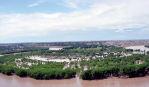
City staff have presented the 2026 overland flooding hazard overview to members of the Emergency Advisory Committee, including critical actions all departments would take in the event of a flood this year. A flooded Police Point Park is seen viewed from the opposite bank of the South Saskatchewan River in this June 2013 file photo.--NEWS FILE PHOTO
bmiller@medicinehatnews.com
According to Medicine Hat’s Emergency Advisory Committee, overland flooding is the most consequential hazard identified in the city’s hazard risk vulnerability analysis, used to calculate potential consequences to residents and property.
To clarify, the city’s highest risk event is a windstorm because of its probability to occur more often. But the most consequential hazard is flood due to the destructive potential impact on the community.
Due to an annual high risk, EAC members presented a walkthrough simulation on how the city would respond if an overland flood occurs this year. If one did occur, the plan includes 64 critical actions to be taken to ensure a co-ordinated response within all city departments.
EAC members were told Tuesday that their role in an emergency situation involves co-ordinating response efforts between departments such as municipal works, environmental utilities and community development.
The city has invested heavily in mitigation and infrastructure since 2013 to protect against overland flooding, and relies on the River Forecast Centre for predictions and guidance during potential events.
In the event of flood this spring, the city’s property protection group has developed a protection system made up of earth and berms located in low-lying areas of Medicine Hat, including near the water treatment facility and power plant, as well as Harlow, Riverside and Strathcona Park.
Earth berms are also located along Industrial Avenue and River Road and have been designed to withstand a peak 100-year flood event with an additional metre of freeboard.
In terms of water flow from the South Saskatchewan River, berms are able to offer protection against a 5,480 cubic-metre per-second flow, plus one metre of additional protection.
“What that means is just essentially a built-in factor of safety,” said Shona Dickie, manager of community support and community development.
The city can also deploy a variety of temporary measures, including barriers, barricades, muscle walls, plugs and pumps to areas once the risk of flood is identified.
Staff highlighted the effective Demountable Barrier system that has been installed in six locations around the city, including Lions Park, Riverside and along River Road, protecting important infrastructure and homes.
“We also utilize Hezco and barricades, which are made up of systems of caged baskets with fabric insets designed to hold back flood waters once they’re filled with fill material and covered in poly,” explained Dickie.
The city can also deploy one of its two portable muscle wall systems that are four feet high, pre-filled with water and then covered in poly once erected to hold back flood waters.
The city can also utilize storm system plugs and pumps to handle storm water or additional water during a simulation rain event.
“While the berm and other temporary measures help keep the flood waters out and protect our city, we need to ensure flood waters do not back up through our storm system and into the contribution areas,” said Dickie.
To help prevent backups the city has installed 39 inline checkmate valves at locations considered “at-risk” of storm outfall.
“They allow for the release of storm water during a rain event, through the catch basin out of our outfalls, but they self-seal during high flow events to prevent water from backflowing up,” added Dickie.
City staff also undergo annual training to prepare for flooding events, including learning how to assemble demountable barriers and setting up systems in isolated areas.
Annual inspection on all flood infrastructure, including more than five kilometres of berms, are conducted, while routine maintenance of sandbaggers, pumps, lighting systems remain ongoing.
The city has identified all locations where temporary measures may need to be implemented due to floodwater impact levels and flow triggers. This predicts a theoretical timeline of what will be impacted by the flow of water and where to send crew members to first respond.
Additionally, the city has a comprehensive plan for when supplemental plugs would need to be installed in the storm system and where pumps would need to be situated at the same time to manage storm water.
The response plan has also identified risk levels for when bridges are needed to be closed during high flow events.
The city also provided an update on its role of providing social services to residents in the event of evacuation, and its ability to provide temporary lodging, family reunification and up-to-date information through its reception centre.
Evacuees would also be provided with social support for mental health issues, translation services and animal services, plus transportation options for residents housed in hotels and other group residences.
The most recent high impact overland flooding event occurred in 2014, however several neighbourhoods in Medicine Hat were devastated by the 2013 flood.
Other recent flooding events occurred in 2005, 2010 and 2011.
According to the most recent weather data the region has experienced a high snowpack this year.