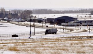
Gershaw Drive in Medicine Hat stretches to become Highway 3 in Cypress County, were a proposed agri-business corridor is part of proposed changes to a multi-jurisdictional development plan that will be discussed at a public hearing tonight.--News Photo Collin Gallant
@@CollinGallant
Three local councils will stage a joint public hearing tonight toward passing updates to the Inter-municipal Development Plan between Medicine Hat, Redcliff and Cypress County.
It will also aim to smooth out several controversial issues left over from the last update to the planning document five years ago, when the parties convene at 6:30 p.m. in the Medicine Hat College theatre.
The three partners passed the original plan in 2009, laying down general planning goals and zoning in areas of common interest along the common boundaries of the city, town and county.
It also gives each the opportunity to comment on specific development applications on those lands which have come before another council.
The joint public hearing in 2020 featured a host of complaints from landowners in that area who said the city has too much control on areas south its limits, in essence “blocking” them from apportioning land for acreage development.
Local landowners also questioned the creation of a designated “greenhouse corridor” along Highway 3, which was eventually removed from the finalized draft, as well as raised questions about runway expansion at Medicine Hat Regional Airport.
If a new proposal is adopted, restrictions on some acreage development would be loosened, while elsewhere, three sections of land near Highway 3, just south of city limits, would be denoted as an agribusiness corridor.
The new slate of amendments was to be subject of two open houses last fall after the three parties announced a general agreement on updates in September.
At that time, city planners told media that while further land for south-side residential development may not be needed for several decades, the presence of small country subdivisions makes the land arrangement more difficult, as well as drives up the costs of utility provision.
A new proposed map shows 17 quarter-sections within a mile of city limits would be subject to restrictions, though 19 other quarter-sections south of that would be opened up. County farmland nearest Township Road 120 is still designated as a future industrial and commercial “growth zone.”
Among other major changes:
– The general alignment options for Highway 3 twinning would be added ahead of proposed construction;
– Some land north of Redcliff, denoted north of the town, would expand;
– Move the eastern boundary of the planning area to Highway 41, from one mile further east at present;
– Plan boundaries would also be adjusted to nearest property lines in some cases, rather than a proposed route for a long-term Trans-Canada Highway ring-road project filed by Alberta Transportation.